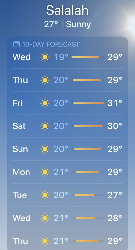
I’ll begin this week’s update with some good news ( in short supply in the Middle East this past week 😳 ). There’s also an update on our current status ( as of March 7 ) at the end of this blog ( more good news ).
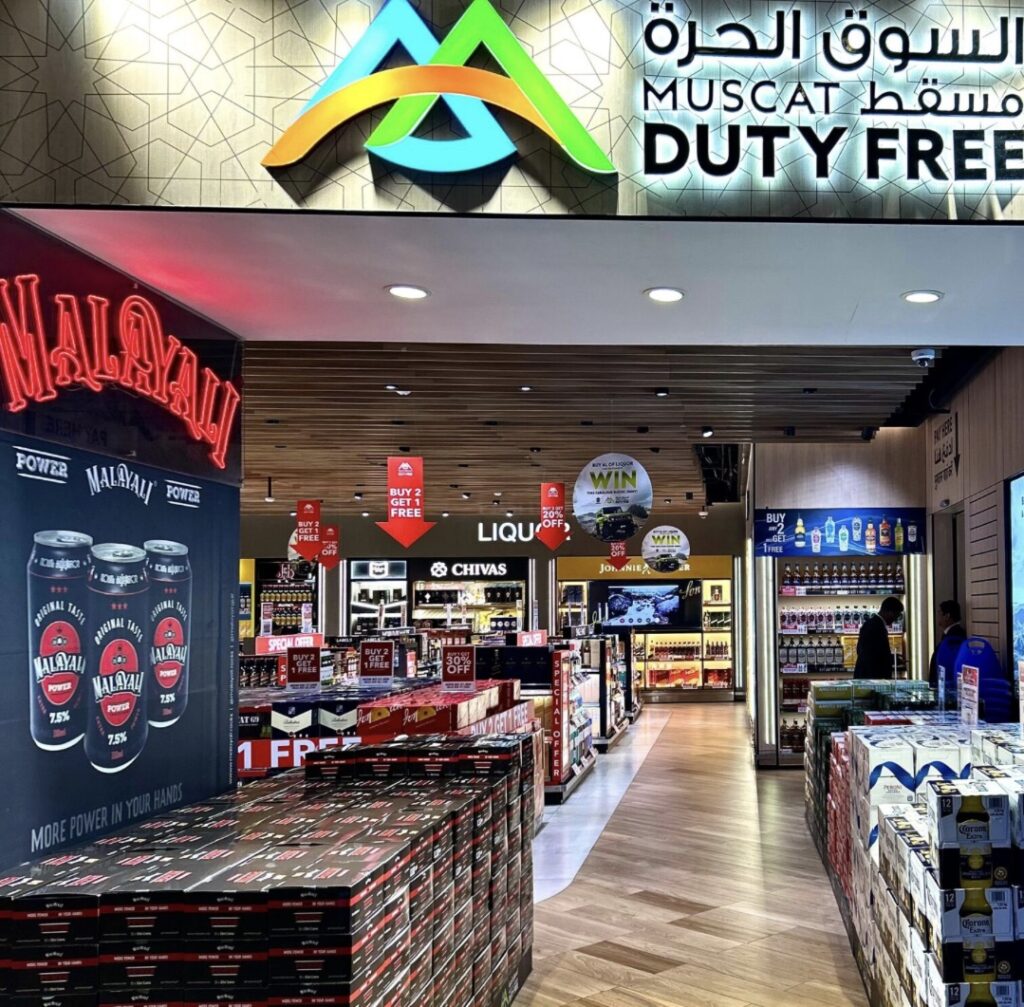
Upon arrival in Muscat, Oman, we were (finally !) able to buy some beer and wine (at the airport duty free store )🥳. Not the world’s best value duty free store, but hey, beggars can’t be choosers as they say, and we were very happy just to have it following a month of effective prohibition in both Saudi and Bahrain. I bought a case of Corona and a couple of bottles of wine for Lois. The friendly fellow at the airport store then asked me if I “perhaps wanted a second case ?” ( their liquor allowance is quite generous here ). “No, thanks”, I replied. “Are you sure ?”, he asked, then added that “……it costs 3 times as much in town, and that’s if you can get it – it’s Ramadan here now, you know”. A good salesman – I took the second case 🙂.
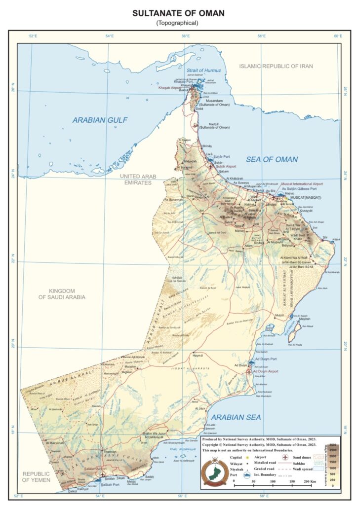
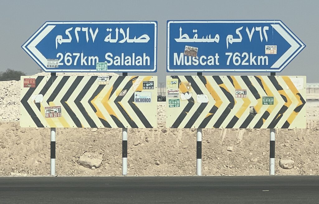
Upon arrival in Muscat, a sight for sore eyes ! Beer, wine, spirits, all available, and very welcome after none in either Saudi or Bahrain.A map of Oman, showing the capital, Muscat, in the north and Salalah ( where we would spend most of our time here ) in the very far south. Note the proximity of the much talked about “Strait of Hormuz”, which sits just above Oman.
While not nearly as big as Saudi, as with Saudi there would be some very long drives here in Oman, too. Given the distances, our plan was to tackle the very long drive first up – Muscat to Salalah via the inland ( desert ) route. Everyone we’ve spoken to who had been to Oman before us told us we had to get to Salalah. A really pleasant small city right by the ocean, with palm trees and camels everywhere, along with beautiful beaches – we had long anticipated it. The vibe, we had heard, was very laid-back, something that would appeal after the long drive to get there ( just over 1,000kms ). A quick overnight stay in Muscat with old friends Barb and Al ( teaching in Oman now ) got us rested up for the long drive ahead ( thank you for the superb dinner and gracious hospitality Barb !). The plan was to get to the very bottom of Oman and then slowly work our way back up the east coast, taking in its considerable sights before wrapping up back in Muscat for a few more days visiting again with our friends.
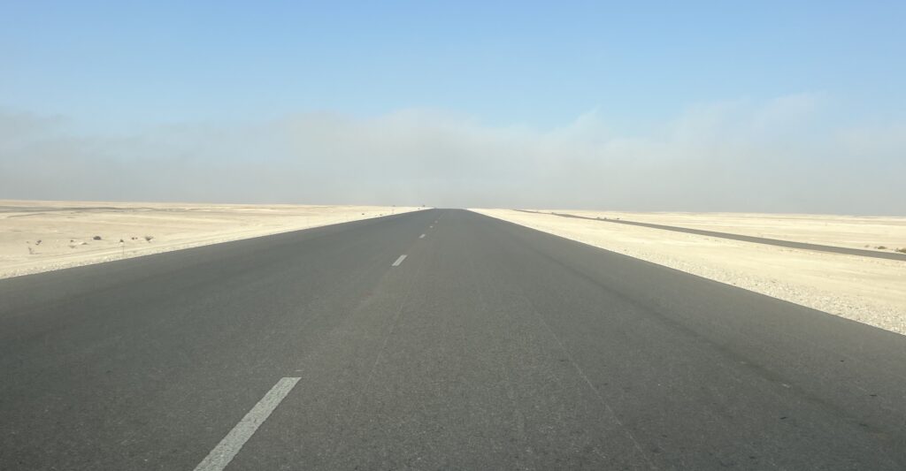
The road south to Salalah often looked like this. Not always…….but often ! It gets mesmerizing after a while.
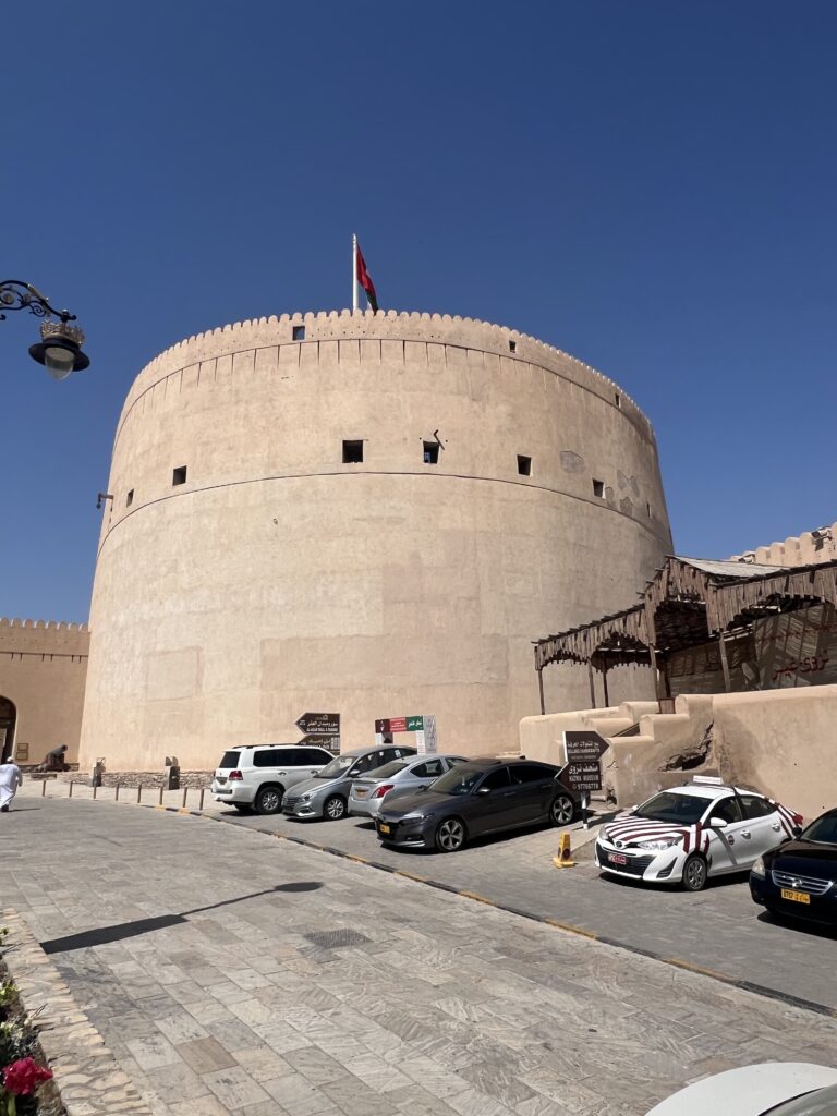
It all started off so well. The route, while mostly boring desert, took us via historic Nizwa and its famous fort, a nice respite from hours on the road. Finding a hotel in the desert after leaving Nizwa was a challenge but we stumbled up one in the end. We asked in the first town we crossed ( none there ) and were told there was “one” about 120kms further south- like I said, lots of “nothing” here, much like Saudi.
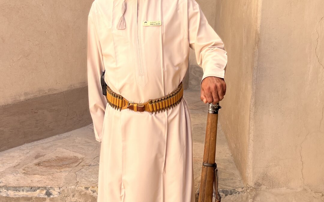
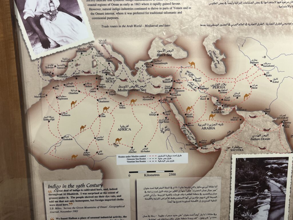
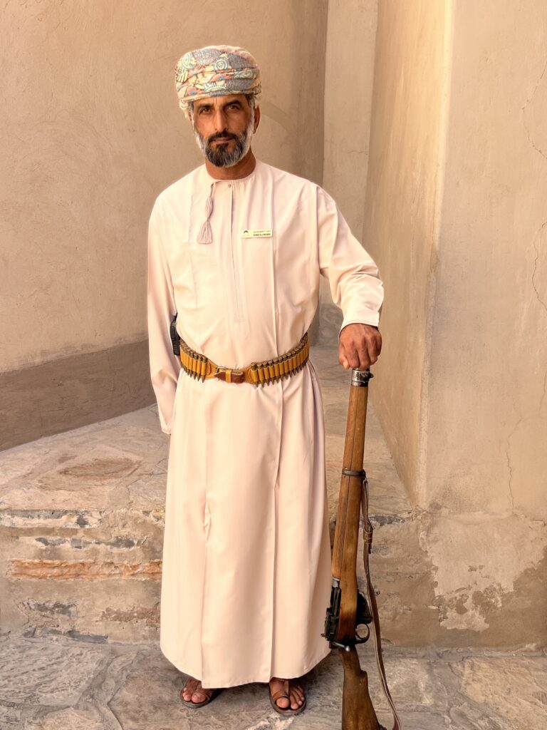
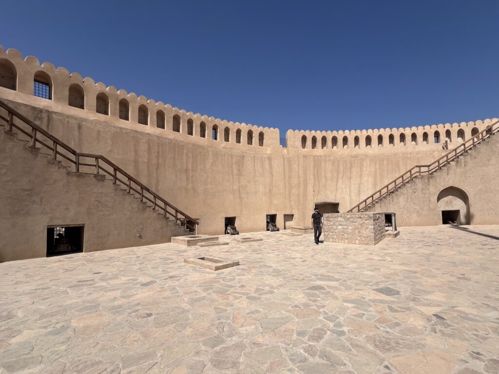
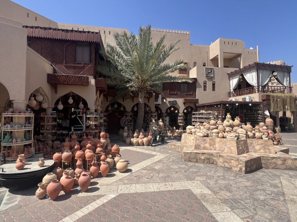
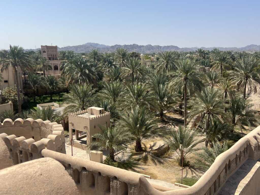
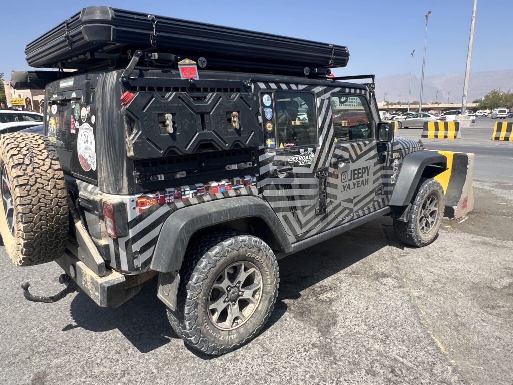
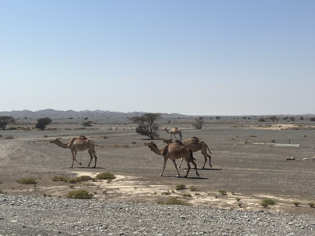
Historic Nizwa Fort, protector of several vital trade routes in days gone by. Very nicely restored and contained an excellent museum.Traditional trade routes across the Arabian peninsula and beyond.Traditional Omani guard, Nizwa Fort. We thought this fellow looked like he came straight off a Hollywood movie set.Inside the fort.Nizwa market,Oasis view from the fort. The setting was postcard-like.Saw this German – plated overland rig parked at Nizwa. I was always happy with our little rental car……until I would see one of these !More scenery on the road to Salalah. There was some variation in the landscape and periodic herds of camels to keep us company.We split the 1,000+ km drive into two long days.Map showing the relative location of Salalah ( blue dot ). Almost in Yemen.
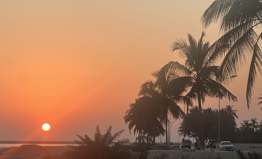
Having reached our AirBnb in Taqah (near Salalah), we were both ready to relax, kick back, enjoy the ocean view and sip on a glass of wine and cold beer. Indeed, we did just that for the first few days – swam, hiked, walked the beach, shopped, toured around and just generally enjoyed the place. The weather was divine, making it all so seemingly perfect…….
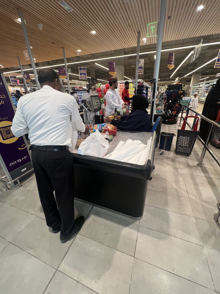
Sunset, Taqah beach, out front of our AirBnb, looking east to the Arabian Sea.AirBnB unit, Taqah ( near Salalah ).Interesting- when we shopped there was always a well dressed employee to pack your groceries. We don’t usually see that at home.One could not have ordained more perfect weather. Divine.Salalah.
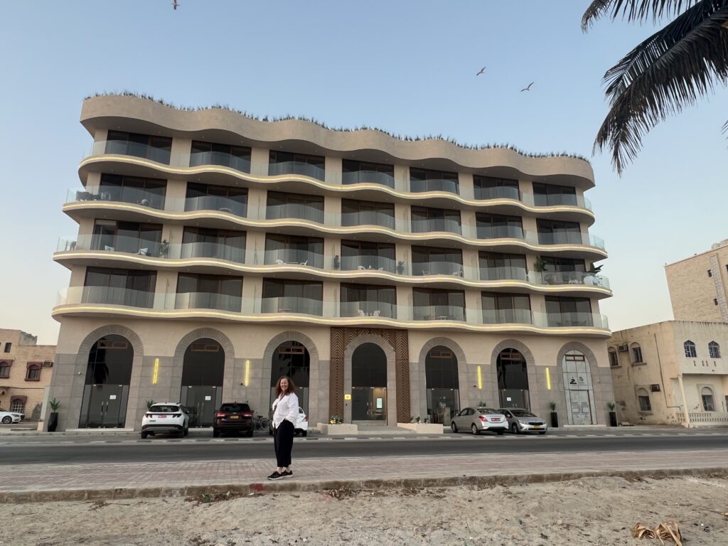
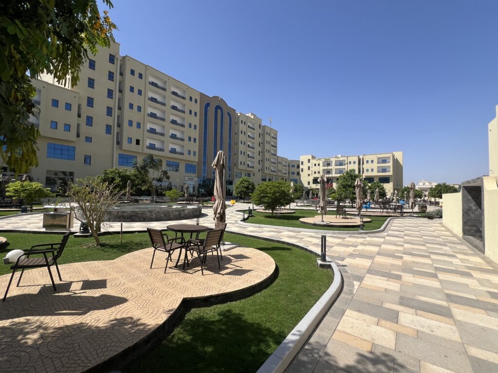
Then all hell broke loose. News broke of the Israeli/US attacks on Iran, death of the Ayatollah and senior Iranian military personnel , and retaliatory Iranian strikes on Israel and US interests in the Gulf states. While we felt very safe in Oman ( far enough away, and initially not attacked by Iran ), that would change in the coming days. In the meantime many hours of every day were spent glued to the TV ( Al Jazeera, in English, giving some excellent coverage ), attached to our phones and IPads, watching international news and fielding calls, texts, WhatsApp’s and emails from concerned friends and family. Very touched by the concern from everyone, thanks to all who reached out. At this point we decided to move into Salalah proper to be closer to the attractions and to meet up with some old Swiss friends from our Turkey travels. Found a wonderful hotel with great amenities so at least we could spend this increasingly tense time in the company of friends, who were, in a sense, in much the same predicament.
Needless to say, while we loved Salalah ( and spent almost a week there by the pool and beach ), much of it with Swiss friends ( Martin and Maria ), ultimately events took a turn for the worse and the “war” ultimately touched us, even in Oman. Just north of us, in the port city of Duqm, a drone strike hit a warehouse at the port. No deaths, no real damage, and the Iranians ( typically friendly to the Omani’s ) actually denied firing it. It shocked everyone here – after all it was the Omani foreign minister who was doing the mediating between the United States and Iran, prior to hostilities starting ! Of all the places here that absolutely no one unexpected them to hit, Oman was top of the list- no US bases, no other US military installations, and no permanent US military personnel are here, unlike the other GCC states. But, it happened.
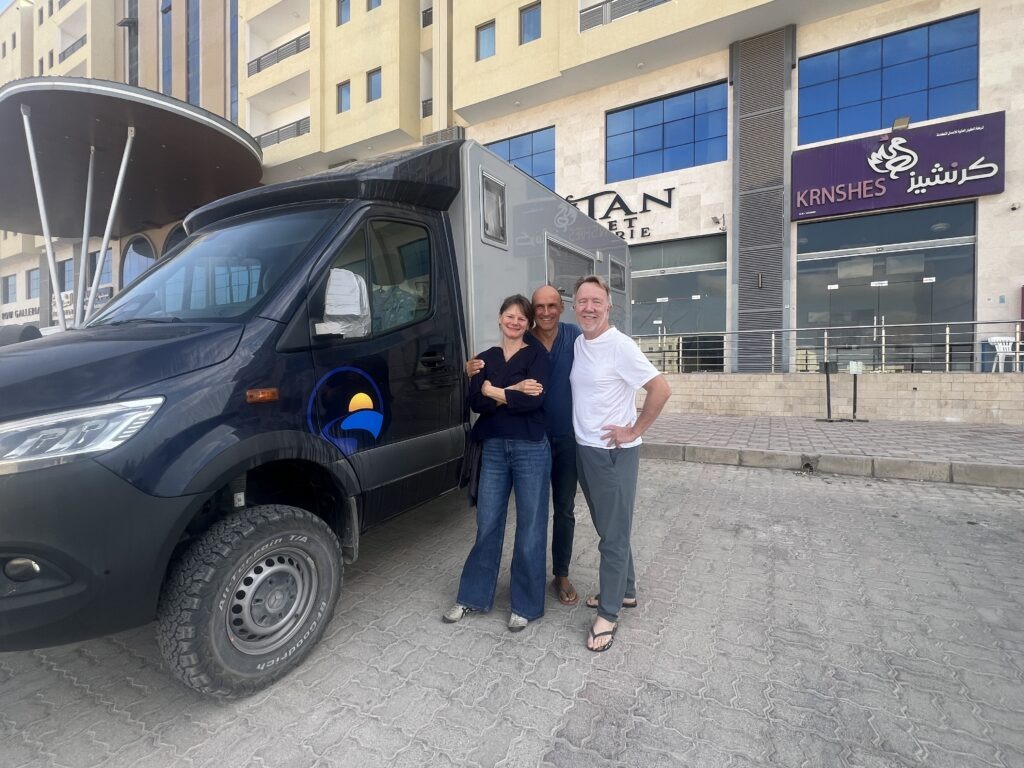
Martin and Maria, Swiss overlanders who we’d first met in Konya, Turkey, and who drove their Sprinter across Iraq and on into Jordan and Saudi. Had a feeling we’d cross paths again and we enjoyed a few wonderful days with them in Salalah. Note the duct-taped side mirror ( courtesy of a crazy Iraqi driver in Baghdad ! ).Having moved in to Salalah proper we stayed at the wonderful Plaza Hotel And Resort. A great spot, with pool, beach club, and the best Indian restaurant we could find in Salalah!
At this point we decided it was time to secure a flight out ( subsequently even a second flight out – yes, we booked two, to different destinations for some added insurance ), and start thinking about when to start making our way back to Muscat. We were not fearful ( no one here was at that stage ), and certainly we were not rushing for the exits, but we did want to secure seats for the future in the event things deteriorated further at which point getting out maybe more challenging – or even impossible. We did that and chose a date to leave Salalah a few days ahead so we could get to Muscat in time for the flights out we had booked. Full details on that in the upcoming blog – interesting times we live in, to say the least 😳.
Till next week…
Alert: Just prior to this blog post being published, everything changed, we scrambled back to Muscat and managed to safely exit Oman. I will leave the tumultuous details of our final days there till next week.
NEWS UPDATE: As this update goes out folks are no doubt seeing the rather unsettling news coming out of Iran. Since we’ve already had notes from concerned family members, thought I would preface this blog with a note advising that we are safe, and currently in southern Oman. We’re monitoring events closely and are ready to adjust plans as needed ( seems we may need to ).
It’s fair to say that the experience in Uruq Bani Ma’Arid was certainly a highlight of our time in Saudi Arabia , if not the highlight of our experience so far. It’s not like it was the desert itself that was new but actually getting up onto the dunes and racing up one side of them and slowly drifting down the other in a 4 x 4 vehicle was an experience we’ve not enjoyed before. Seeing the famed Empty Quarter from a high vantage point was also a delight – while we didn’t see an Arabian Oryx, the few wild gazelle’s were a nice consolation prize.
This is an Arabian Oryx. So disappointed not to see one at Uruq Bani Ma’Arid. We even tried the Riyadh Zoo but it was “temporarily closed”. May get another shot in Oman.
From there it was a solid two day drive back to Riyadh where we planned to spend a few days relaxing, sightseeing, and prepping for the next stage of our Middle East travels. There was not a lot in Riyadh we wanted to do, but what we did see was enjoyable. A couple of popular attractions were unfortunately closed. The city is not only huge in terms of population, it is extremely spread out and it takes an eternity to get from one side to the other. Having driven through it from the south to the north side (where we stayed) we were able to see just how challenging the driving was in this city- in fact, while in Riyadh, we actually had a “first”. We parked the car and used the excellent Riyadh Metro to get around, a) because the Riyadh metro is so good, and b) because the drivers are so bad and the traffic is incredibly brutal ! Normally, we don’t hesitate to drive around the cities we visit (and that’s when we are travelling in a 7m long van !) -here we only have a small car and have still found it incredibly difficult at times – the drivers here take terrible risks and do very unpredictable things, more so than anywhere else we’ve been. We see accidents all the time and the number of new, and near new, cars that are banged up is shocking. Many are never repaired as they know they’ll just be hit again. Lois has often looked at me in Saudi Arabia and said, “Glad you didn’t bring the van here, now….?” While I very much miss not having it with us right now, some days indeed I’m glad we did not bring it here from Greece.
Not only did we encounter a lot of very dangerous driving, we saw countless badly overloaded vehicles – these were everywhere, very unstable and top heavy.
I’ve often commented in this blog on how friendly and welcoming the Saudi’s have been, ever since our first day here in fact. It has been at times almost embarrassing – the experiences below will explain what I mean, one on the way south and another, nearly identical situation, on our way from Rijal Alma’a to Riyadh. In both cases, we had walked into restaurants near the hotels we were staying in just to order some simple meals. In the first case, a pizza, and in the second case, some chicken, salad and fries. Both times, Saudi men, standing in the restaurant, waiting for their orders just like we were, secretly approached the restaurant manager, and, unbeknownst to us, paid for our orders. Two separate events, and two separate places, but just days apart. In the former case, we had at least spoken to the men nearby, but in the latter case we had not – yet in both cases they paid our bill and when we insisted that it was not appropriate to do so, and that we would pay it ourselves, they just smiled, pushed our money away, and said “Welcome to Saudi Arabia”. Not something we’ve experienced anywhere else, but totally consistent with the kind of generosity and hospitality we’ve experienced all the way through our travels here – we are constantly offered tea, grapes, bread, dates, water bottles, all free just by walking into stores to buy something else we need. There’s no hidden agenda, just genuine local hospitality. It’s constant …..and amazing. Truly very touching.
The gentleman on the left quietly paid for our take out dinner one night. Absolutely, steadfastly, emphatically refused to take our money, repeatedly saying, simply “Welcome, welcome……welcome to Saudi Arabia !” The very same thing would happen again in Riyadh a few days later.Black camels. A first for us !There is always a camel herder wherever you see camels ( it seems ). A hot and lonely job.True to our web address, much of Saudi was indeed “one endless road”…!Not a lot of formally designated “rest areas” as we know them, but easy to just pull over ( pretty well anywhere ) and take regular breaks.
After the nightmare of traffic and driving into Riyadh it was a relief just to get into a nice hotel and rest up – no driving for a few days now, just planned to relax and explore the city. One of the city’s big attractions is its National Museum – highly rated and well worth the few hours we spent there, it chronicles the whole history of the country, it’s evolution into its present form, the emergence of Islam, the reign of the Ottomans, the unifying role of the much revered King Abdul Azziz in the early 20th century ( don’t miss the late king’s car collection if you go there !), right up to the discovery of oil in 1938 – which, of course, changed everything in Saudi. The museum was a fascinating look into this amazing country.
I mentioned really missing our van here in the Middle East. That said, it’s certainly been nice to have the space of a hotel room. Without exception they have all been very big!A uniquely Saudi twist – on the new Riyadh metro,men travelling alone use these carriages….….while ladies ( alone ) or “families” ( couples with or without kids ) travel in these carriages. There is also a “First Class” section ( more expensive ) which we have never seen on an urban metro anywhere else. We eventually got the hang of it !National Museum, items from centuries back. A section detailing the discovery of oil and how it’s extracted. It hugely impacted Saudi’s transformation into a modern country.Former King Abdul Azziz’ had an impressive car collection – this classic Rolls Royce donated by Winston Churchill, no less !Last week a “Holden” car, this week Vegemite in a Saudi supermarket – heaven for expat Aussies !
During our time in Riyadh, we made a minor change in our forward plans. Rather than travelling directly on to Oman, we decided to visit Bahrain first. It’s only a 4 and 1/2 hour drive from Riyadh to Bahrain, and whenever we can go by road, rather than flying, our preference is always try to do that if it’s practical ( this is an “overlanding” journey after all ! ). There was, of course, more to it than just a little extra overlanding – Bahrain is a very popular R&R destination for Saudi’s themselves principally because it’s close, but more practically because it’s a lot more liberal than Saudi Arabia – one can easily get beer and wine there and the whole vibe is reportedly just a little more cosmopolitan, much like it is now in Dubai. Since we’re not sure we’ll revisit the UAE, a very slight detour now to Bahrain made sense. Oman, we’re told, is much like Saudi so a break between the two just seemed wise. That at least was the logic when we booked the tickets and hotels. Subsequent to that Lois did a little more in-depth Googling and discovered that those more liberal lifestyle features of Bahrain apparently disappear during Ramadan, and of course, Ramadan ( which lasts a full month ) begins the day we arrive in the country. Too late to change plans now…we shall have to wait and see !
Four days of relaxing by the pool in a nice Bahrain hotel was something we were really looking forward to, as was the prospect of a beer and glass of wine after 3 1/2 weeks of effective prohibition in Saudi. We would get full value on the former, though ended up being sadly disappointed on the latter ( more on that later ). Leaving Saudi, there was still one nice little surprise in store for us.
The logistics of moving around the region made it much easier to visit Bahrain from Saudi Arabia, just a 4 1/2 hour drive with the new King Fahd causeway linking the two states.
The Saudi rental car, which started in Riyadh, had to be returned to Riyadh. I had asked if I could drop it in Dammam ( which is just across the causeway from Bahrain – one could then literally “Uber” over to Bahrain from Dammam) but was denied. That meant bussing was the only “overland” option. Still determined to do that, I booked tickets on the express direct bus to make the journey as fast as possible. Much to our surprise ( and joy ) it turned out that we were the only two people on the aforementioned “bus”. So instead of sending just the two us off in a full sized tour bus, SATCO ( the Saudi national company ) provided a nice new Ford Expedition SUV with two drivers who personally took us across to Bahrain – much faster, more comfortably and ( since we were the only passengers ) drove us direct to our Bahrain hotel ! What a wonderful way to depart Saudi ( where the surprises just never stopped coming ) and a beautiful and convenient way to arrive in Manama ( Bahrain ) ! Sometimes the gods just smile on you, and this was one such occasion.
Chauffeur driven from Saudi to Bahrain as it turned out. Nice way to travel !
It was actually an interesting drive across the eastern desert in Saudi- while we cruised comfortably at 140km/h in the big SUV, the traffic was incredibly heavy, Highway 80 being the main road to Dammam, Al Khobar and Bahrain. We’d expected to pass at least some of the massive Saudi oil facilities ( in all our time in Saudi the picture below is the ONLY kind of oil facility we ever saw ) – I guess they are all further north. As soon as it turned to dusk, hundreds of cars and trucks started pulling off to the side of the road to break the Ramadan fast ( one can’t eat, nor drink, between sunrise and sunset during Ramadan ). It was quite extraordinary, looked like dozens of picnics occurring right beside a very busy highway just as it was getting dark ( hence no pictures ). The border crossing was slick and took only minutes at each side – a final “Thank you for visiting Saudi Arabia” as we departed, and equally warm welcome by the Bahraini customs official.
The only oil “facility” we saw in all our time in Saudi. We expected to see huge refineries all over the place but seems they are concentrated just north of where we travelled.
It did not take long to see the difference between these two countries; Saudi – huge, and very conservative, while Bahrain is tiny and ( first impressions anyway ) far more liberal. Being Ramadan the streets are alive at night and we saw many people out and about. Hardly an abaya and not a single niqab to be seen, a stark difference from Saudi where much more conservative Muslim attire for women is the rule, not the exception.
We really enjoyed our time in Saudi but in three weeks there ( and all of it uninterrupted sunshine ) we never swam in a pool or the ocean. Nice to have a hotel pool ( and feel comfortable using it ) in Bahrain.
For the most part we simply relaxed in Bahrain, as was the plan ( actually nice NOT to have a car for a few days ). The hotel pool made it easy and when we weren’t enjoying that there were a couple of excellent souks ( markets ) to wander, an impressive waterfront to walk and a bustling downtown to visit. The old Portuguese fort in Bahrain is probably the major historic feature, conveniently located close to our hotel – one of the few “old” buildings in Bahrain, the city is of course far better known for its stunning modern buildings, the twin towers of the Bahrain World Trade centre being the standout. It was the first building in the world to have wind turbines designed into the structure.
Bahrain Fort, built by the Portuguese in the 1600’s.Bahrain FortView across the fort ruins to Manama, the capital of Bahrain.Downtown souk ( market ).Manama’s stunning World Trade Centre building. Complete with built in wind turbines !Spent an enjoyable afternoon walking around the harbourfront marina area.Plenty of money in this town !
As with the last days in Saudi we continued to navigate the strictures of Ramadan while here in Bahrain – not easy when you are a tourist. While you can buy from stores and restaurants during the day, you absolutely cannot eat or drink in public until sunset. No early morning Starbucks, either. All closed. Yes, it takes a bit of getting used to and we found ourselves walking back to the hotel during the day just so we could eat and drink – while Lois probably could have managed without food during the time between sunrise and sunset ( having far more willpower than I ! ), I absolutely could not and can attest that Ramadan is brutal for habitual “grazers” such as myself.
Our time in Bahrain was nonetheless very enjoyable- we can see why it’s a favourite among expats. Oh yes, that beer and wine we’d looked forward to in Bahrain ? Turns out it’s effectively a dry state during Ramadan ( perhaps we’ll get luckier in Oman 🙂)!
In addition to a leisurely Red Sea coastal drive there were two major attractions ahead of us in the southern part of Saudi Arabia – historic Rijal Almaa ( just west of Abha ) and, “Inshallah” ( god willing ) with the necessary permits, a visit to the edge of Saudi’s famed Empty Quarter, the Protected Area of Uruq Bani Ma’arid. First, we had to continue down the Red Sea coast for a few hundred more kilometres.
Found a nice warm, shallow bay where I wanted to take a dip in the Red Sea, but……..…..apparently not in this area !There are a lot of things one CAN’T do on or near a Saudi beach !
For reasons, we still can’t explain everyone suggested that Abha was the ideal jumping off point for a Rijal Alma visit so following the necessary layover en route we made Abha our first port of call in the south. The drive down the coast was uneventful – unfortunately only part of the time were we actually on the coast, but when we were, it was a pleasant relief from the endless desert inland. Once again we were surprised by the absence of just about anyone on any of the beaches, especially given it was a calm, clear and very warm day. It seems that beach-going is just not really a very Saudi thing ( when we did find what looked like a great spot with a little privacy, there was a massive sign saying “No Swimming” 😟). Perhaps it will be easier in Oman.
Typical of the Red Sea coast. Even when there were beaches we almost never saw anybody on them, despite it being a Saudi “weekend” and perfect beach weather.As we drove down the Red Sea coast we saw several huge plants – not sure what they were at first then realized ( after seeing this sign ) that they were desalination plants. Saudi has literally no water ( I can’t recall seeing a river here anywhere ! ) so it all comes from the sea.
Abha is a nice, smaller Saudi city located at a relatively high 2300 metres ( 7,500 feet ) ASL- the much cooler weather at this elevation attracts many Saudi’s, especially in the hot summer months and they all know Abha. It actually wasn’t very busy at all when we were there, much to our surprise and delight. Continuing on our recent history of personal stumbles ( I’d had a badly stubbed toe in Jeddah ), Lois then put her back out shortly after we arrived in Abha. Two of the three days there she was mostly bed ridden ( but is all well now ). On our last day there we made the excursion to majestic Rijal Almaa – the VisitSaudi website describes it better than I could: “This stunning village, with its vibrant stone buildings and unique architecture, showcases 700 years of history. Recognized globally as one of the best tourist villages, Rijal is a treasure trove of cultural tales and rare exhibits”. Located at the intersection of old trade routes and a layover for pilgrims headed north to Mecca, Rijal is history preserved – fascinating to walk around it, explore the museum and wonder at bygone times. It is indeed, as the Saudi website says, very well preserved.
Approaching historic Rijal Almaa.Main square, and museum, Rijal Almaa.This is a major tourist draw in southern Saudi Arabia, it was a beautiful day in high season, and yet the place was almost deserted.Rijal, view from above.Pretty sure this part was restored but it beautifully matches the original behind it.
An additional thrill in going to ( or leaving from ) Rijal is the opportunity to drive one of the Middle East’s classic road trips – the short, but spectacular “Rijal to Al Soudha” road. We did the uphill run ( to Al Soudha ) and it really challenged our little rental car – but was a ton of fun ! Al Soudha is in fact Saudi’s highest peak so driving anything on that road is a serious grind.
One of the great joys in getting to ( or leaving ) Rijal is the opportunity to drive the famously steep, curvy and twisting Al Soudha road. Reminded us very much of the Stelvio Pass in Italy. It’s the highest point in a Saudi. The road to Rijal Almaa via Al Soudah is considered the most dangerous in the Middles East.
Having come across an article written about Uruq Bani Ma’arid by a young European couple we were hell bent on getting there. I already knew about the vast expanse of the Empty Quarter and wondered how and where we might best get to explore it during this trip to the Middle East – I figured this was as good an opportunity as any. In fact, it was probably better than any other since the necessary permits are issued free by the Saudi National Centre for Wildlife and they throw in a two hour 4 x 4 tour of the sand dunes along with wildlife spotting opportunities – incredibly, also free 😳. Just something you do not see very often. My guess is that right now they are simply testing this place for a broader “payable” inclusion into Saudi’s list of better known and nationally supported attractions – they certainly seem to be putting the infrastructure in place to do so. It definitely deserves to be more aggressively promoted.
We had website issues in obtaining the necessary permits, followed by a series of emails that were not promptly addressed, followed by some back-and-forth on WhatsApp, and finally followed via a phone call to confirm that, finally, we had, at the 11th hour, been issued the visit permits. Now pumped to see it, I can only say we were not disappointed.
Never happier to see any sign in Saudi. It had been quite the challenge to get permits to visit Uruq Bani Ma’arid but was it ever worth the wait. An absolute highlight of our time in this country. Spectacular.
To put the location in perspective, I have attached a map of the region. We were already almost at the very bottom of Saudi Arabia, then had to drive due east ( just above the Yemen border), literally out to the middle of nowhere. Not hard to see why so few people who aren’t already in the south actually come here. A solid one and a half day drive east of Abha and we were finally on the Ranger Station doorstep. Passports checked, vehicle checked, and then parked, we were escorted by Saeed, the Saudi guide to his new Toyota 4 x 4, for the included two hour sand dunes tour. We’d have thought the experience was worthwhile if we just got to look at the huge dunes up close and perhaps saw one or two animals, but there was more. Given that we were only guests for the day I think Saaed gave us a little more time than usual, and gave us an incredibly memorable, 4 x 4 sand dunes experience – actually drove up and down dunes that we simply did not think possible – amazing stuff…! Sighting an Arabian Oryx is the holy grail of wildlife viewing in this park and while we didn’t see the elusive oryx, we did manage to see four gazelle‘s, the animal next down on the list. Hard to imagine how any animal can live out here when we were told that it actually never rains in this region. Apparently they get the water they need from plants. As beautiful as it is, there would definitely be easier places to live if you were a gazelle ( then again there are no predators here )..!
Once inside the “Protected Atea” you are advised that you are entering Arabia’s legendary “Empty Quarter” ( Rub’al Khali ).In places, golden brown/orange sand for as far as the eye can see, spectacular when set against the blue sky on a clear day. The other thing- absolute quiet,Another shot….Picture time ( and shoes full of sand by the end of the day ! ).One of four gazelles we managed to spot – sadly, no Arabian Oryx.Driving on the dunes with Saeed’s Toyota 4×4 ( with heavily deflated tires ) was a blast. Took us up down dunes that we did not think possible !The vehicle was perfect for these dunes and Saeed’s skills were impressive. Some tracks we made.From one high dune, looking out for animals. The Arabian Oryx is the animal everyone wants to see but they are notoriously elusive. We managed to spot 4 gazelles but not an oryx to be seen.Much of the reserve is on a high plateau-one could see for miles from the edge of it.Another shot.
The Empty Quarter touches Saudi, Oman and Yemen and is a massive expanse of barren, dry desert, famous for the windswept dunes such as we saw here. We won’t be going to Yemen but Oman is on the agenda so perhaps we may even get to see it again from the other side. We’d jump at the chance.
The “Empty Quarter”, so named because it covers almost one quarter of the Arabian Peninsula.
Beyond Uruq Bani Ma’arid we head generally back to Riyadh now and one last geographic ( geological ? ) Saudi attraction.
Leaving the spectacular oasis/canyon of Wadi Disah last week, the landscape all the way to Umm Lajj ( on the Red Sea coast ) was probably as boring and monotonous as we have seen in Saudi – lots of sand, lots of camels, and a few small towns in between. More than anything it showed the chasm of difference between the larger cities ( modern, vibrant, generally cleaner ) and the more remote rural areas ( exactly the opposite ). These more remote parts of Saudi are still very quiet and conservative.
Now on the Red Sea coast. It will be a long drive south with stops in Madinah and Jeddah as we head to Abha ( near Jazan ). There will be no stop in Mecca – can’t even enter the city limits unless you are Muslim 🙁
Spent a couple of nights at the large seaside town of Umm Lajj just enjoying its different view ( the ocean at last, after many days of just desert ! ), doing a little shopping, and catching up on washing ( it always takes a day here – nowhere, so far anyway, can one find a self serve laundry and do it in just a couple of hours ). A bonus was that we managed to stumble on a nice restaurant, a real treat after several days of less than appetizing food choices.
This was a first – stayed in a hotel in Hail, where there appeared to be no towels. Turns out they have disposable towels, or “single use” towels ! Prefer normal ones!Here, parked on a beach in Umm Lajj, the first point at which we saw the Red Sea in Saudi.Beautiful warm day, long sandy beach, shallow warm water. Not a soul in sight 🤷♂️Date palms provide a nice backdrop for the beachParked at our hotel in Umm Lajj and came across a first – an Overlander from the UAE. These guys had been all over the world in this rig.From Abu Dhabi, UAE.Another first for us in Saudi- we crossed this street only to realize the traffic light was green for both the pedestrians AND vehicles ! Not sure how that’s possible ?
Mecca is definitely the holiest city in the Islamic world and non-Muslims are not even allowed to enter the city, much less to visit Al Kaaba itself. Medina, next up on our itinerary, is Islam’s second holiest place and non-believers are welcome there. It’s not only the resting place of the Prophet Mohammed, but the city also has other mosques that rank very highly among those that Muslims aspire to visit. There were two in particular that we wanted to see – one that permitted unrestricted access (Masjid Quba – thought to be the first mosque built in the world ) and the other ( Masjid-e-Nabawi – the second mosque built in the world ) that certainly did not ! I was nonchalantly walking through the ( seemingly open ) gates of the latter when suddenly a firm hand clasped my shoulder. The security guard simply asked “Muslim ?”. No, “Masihiun”, I replied ( “Christian” in Arabic ). A solemn and very firm “Not allowed”, followed. Disappointed, as its the Masjid-e-Nabawi (mosque) that contains Mohamed’s tomb, something we definitely would like to have seen. It was only possible to snap a few pictures from outside 😟.
En route to Madinah the landscape was volcanic in places Saw this on an Instagram feed – long road trips seem to be the way to go lol !!!
The city is very conservative and Lois had been advised that in this place a scarf would be required, certainly to access a mosque. One was arranged, but I’d point out that people had, up until now, been at pains to point out that the garment was generally NOT required anywhere else in the country. We’d seen some Saudi women without it and lots of foreign women not wearing one so the advice seemed accurate. Long sleeves, legs covered and generally conservative “wear” seems to be more than enough ( for both sexes ), though there is definitely more focus on the ladies’ coverings. We’ve been surprised just how popular the niqab/abaya still is in Saudi – very widely worn by Saudi women everywhere we’ve been so far. It looks awfully hot to wear right now, I can’t imagine what it’s like when the temperature gets into the 50’s ( and it does !).
Masjid ( mosque ) Quba – Islam’s very first mosque was built on this site and it holds a very special place for pilgrims, many of whom were here today.Lois, scarfed up for the visit.Saw this sign in the mosque – not sure if it meant physically lost or spiritually lost.The crowds were huge here.Inside Quba, non Muslims were permitted here.Madinah’s famous clock tower.Due to Madinah’s importance in the Islamic world pilgrims come from all corners of the Muslim world to visit, many on pilgrimage tours – here some Kyrgistani’s and Uzbeks.Masjid-e-Nabawi, home of the Prophet’s tomb, Madinah.The green dome, inside Nabawi, contains the tomb of the Prophet, Mohammed. This is as close as we could get.For our Aussie readers – never expected to see a classic Holden Commodore SSV in Madinah, Saudi Arabia !
Another 420km drive brought us to Jeddah, Saudi’s Red Sea gem and second largest city. By all accounts, more interesting than Riyadh so we were looking forward to it, the drive down enriched by the sighting of a troop of wild baboons beside the highway. We’d both thought baboons were known only in Southern Africa ( how wrong we were ), the first hint of them being the “Don’t Feed The Baboons” sign a few kilometres before we actually saw them. One immediately jumped on our car – with more beelining towards us we beat a quick retreat. They can, apparently, get very vicious.
We had no idea there were baboons in Saudi, but, minutes later……..….there they were. Admittedly very poor lighting/exposure here, but it was a hurriedly shot picture ( through our very dirty windscreen ) before we drove off as one jumped on our car, while others were coming. Kind of scary-looking up close, these baboons !
Jeddah’s old town ( Al Balad ) is one of its major attractions and was an easy walk from our hotel. Wandering its backstreets and imagining what life was like here back in the day was not difficult as much of the area retains the charm of yesteryear- old traditional buildings with beautiful latticed wooden verandahs. Very Arabic ! Seems the local tourist authority is pouring millions into this area since much of it is under reconstruction, though we had no problem finding many old original buildings, some now converted to boutique cafés and restaurants. It was in one of these cafés just off the main square that we bumped into a young Saudi lady named Sahar. She had travelled and studied abroad and in fluent English gave us some great insights into Saudi history and culture. She was typical of all the Saudi’s we’ve met – warm, chatty, helpful and genuinely interested in our experiences in the country – charming people. Unfortunately a badly stubbed big toe ( right in the aforementioned main square ! ) limited my mobility for a couple of days and hence any further “walking” exploration of the town. It’s long and pedestrian-friendly seaside Corniche, along with the King Fahd fountain ( the worlds tallest) are a couple of Jeddah’s other sites of note which we’d passed on the way in. Will have to do the walk next time we are here !
Jeddah, vintage art poster.Modern, but in the traditional style, architecture in Jeddah.More “original” Jeddah architecture, Al Balad ( old town ), Jeddah.More of the old town,Coffee with our Saudi friend, Sahar, in Jeddah’s old town. Bab Makkah ( Mecca Gate ), on the east side of Jeddah’s old town. It was through this gate that pilgrims walked, or rode, to nearby Makkah.Main square, old town.
Next blog we head to the far south of Saudi and explore Abha and historic Rijal Almaa before heading back east towards the Saudi capital, Riyadh.
The most logical and shortest route to Abha would have taken us right through Makkah ( Mecca ) but since we are not Muslim one can’t even enter the city, much less the Kaaba itself. Not the “red zone” around Mecca, beyond which it is Muslims only.
When planning our route around the Arabian Penisula, for a variety of reasons travelling “anticlockwise” made most sense – so from Jordan the next country on our itinerary was Saudi Arabia, by far the biggest of the Persian Gulf states and hence likely where we will spend the most time – if for no other reason than it simply takes a very long time to get anywhere ! That, and the fact the Kingdom actually has quite a list of world class attractions ( they’d just kept them hidden from us previously).
This will gives a sense of just how big Saudi Arabia actually is. Superimposed here over a map of the USA.
A little background first. Saudi has not always been easy to get to ( it was formerly not really “open” to mass tourism ), nor easy to travel in. That all changed in September 2019 when “the Kingdom” ( or simply KSA as it’s called here), did a full 180 – the doors opened wide, the visa process was relaxed, as were dress codes and driving rules for women. Word spread quickly and perhaps unsurprisingly it’s been an increasingly popular destination since – particularly so with overland travellers. Fortunately for us this time of the year ( Saudi “winter” ) is the perfect time to come.
We came to Saudi for a few reasons but the weather was definitely one. Best time of year to visit ( this is their “winter” ) ! These temps are in centigrade, of course.
First impressions were great, Riyadh has a stunning airport and the entry process was easy, right through till we picked up the car. We have 2 separate phone providers, both with global roaming, but neither “data” pack was connecting, so this left us navigating to the hotel ( at night ) with only map screen shots ( the “blue dot” just was not moving on Google Maps which it normally does even without a data connection ). We made it, but not without some drama, and wrong turns. Fist lessons in Saudi – people drive fast, lane markers are treated like road decorations ( essentially, ignored ! ), and they love big cars and trucks.
Literally, the first store we saw when we landed in Riyadh airport was a Canadian “Tim Hortons” !A little Saudi style vintage art. Riyadh may once have looked like this but no more !We’ve been in plenty of hotel rooms over the years – but never one where room “309” ( ours ) was actually on the 2nd floor !
With the weather looking great we were keen to head north-west right away leaving any exploration of Riyadh until we circled back later. The immediate destination was Al Ula, one of Saudi’s biggest attractions – so much so that this rather small oasis town actually has its own international airport now. People come from far and wide to see this place, obviously. It took two days of driving to get there, long days, yet still interesting as it was our first experience of the country. All was well until a police roadblock just 80kms from Al Ula forced us to do an additional 250km detour to get there. Not what we needed after having already driven 500kms.
Typical scenery en route to Al Ula.This sign we saw often, and at time with a purpose built overpass so the camels could cross from one side of the highway to the other.
The roads in Saudi are generally very good, certainly the main roads at least, all multi lane and usually with 140km/h ( 85mph ) limits. Our first couple of days proved pretty much what we thought – lots of desert, monotonous at times, but periodically interspersed with unique red rock bluffs and always the ubiquitous camels. Have seen more camels so far in Saudi than anywhere else – far more than Jordan.
As for Jordan, all road signs are in Arabic and English in Saudi. Easy enough to learn the Arabic numbers, the written language – indecipherable ! Note the distances ( and we started in the middle of the country ) – Saudi is huge.
Pulling into Al Ula it was more of the aforementioned red rock bluff scenery, mixed with acres and acres of palm trees – Al Ula is the quintessential oasis town and it’s easy to see why it has been a travel crossroads for centuries ( and is now becoming an international hotspot as well ). Tellingly, while we were there an international bike race was held over 4 days ( the Al Ula Tour 2026 ) which attracts some of the worlds finest cyclists. While the cycling was not our bag, Al Ula’s other attractions kept us busy over the next few days.
The road closures caused by the cycling event caused us some grief getting around at times.
The “Old Town”, while slightly kitschy, portrays Al Ula as it used to be and was enjoyable to explore, the mud brick buildings in various states of repair. The heart of it all, ”The Oasis”, is a wonderfully cool and tropical-like area fun just to wander through – interesting to see how many things they grow out here in what is essentially the middle of the desert. The area has a lively cafe scene ( but no “bars” – alcohol is an absolute “no no” in Saudi – that was not relaxed back in 2019 ). Beyond the oasis and old town there are a few other big name attractions in the town, two of them we got to ( Maraya and Elephant Rock ) while we could not get to Hegra ( the Petra “lite” Nabatean rock formations ). Unfortunately, unlike Petra, Hegra has visitor caps and requires joining a “tour” to enter ( not something we like as a rule ) and the tourist volumes here for the international cycle race meant they were booked out long before we arrived. The Elephant Rock was impressive and the Maraya ( “mirror” ) building and setting was nothing short of stunning – I’ll let the pictures below tell the story.
Part of the “Old Town”Old Town.Rock formations around Al Ula, which reminded us of both the the “Hoodoos” at Bryce Canyon in the US and some of the rock formations around Karijini NP in Western Australia.One of the many boutique coffee shops around the oasis at Al Ula. Enjoyed a nice breakfast here.“Maraya” ( mirror, in Arabic ) is the world’s largest mirrored building. It’s stunning, and contains a restaurant and conference centre. That’s Lois beside it giving some sense of its size. While not an exceptionally hot day when we visited, walking past the sunny side and feeling the reflected heat made it feel like a furnace !It’s the setting, as much as the building itself , that makes this place so impressive.We’ve seen a few “Elephant Rock’s” in different places but this was the biggest and most realistic – the eye and mouth especially. One sits and watches as the sun sets on it providing a variety of colours. I had not been missing our van that much…..until I saw this at Elephant Rock ! 😟
Beyond Al Ula, there was one major attraction remaining in the northwest of the country that we were absolutely determined to see – Wadi Disah. Often called the “valley of palm trees”, Wadi Disah is a stunning lush mountain valley, known for its towering wind-carved sandstone cliffs and natural freshwater springs. Access is by 4WD vehicle only so we hired a local with an indestructible old Landcruiser who took us 7km into the wadi. Spectacular ride, amazing scenery and we were appreciative of doing it in an older vehicle – it’s pretty rough going, would not have taken the Sprinter in even if we had it with us. Another long drive to reach Wasi Disah but very glad we did.
On the way to Wadi Disah. Sometimes the camels get lazy, I I guess !First sight as we 4×4’d into Wadi Disah.Metabh, our driver. Skillfully navigated his trusty Landcruiser through some pretty serious “4×4 only” terrain.Picture time at one of the more scenic stops.Distant view of the formations at Wadi Disah..Seems every “tour” we go on it’s just us. Room for 6 or 8 but it was obviously a slow day and he agreed to take just the two of us.Lots of thick reeds, water and rocks.Ditto.Picturesque no matter which way one looked.
From Disa, we’ll travel over to the Red Sea coast and head south, but more on that in the coming blog.
The PanAm completed in April, 2022 and with the truck camper sold, we shipped our new Sprinter van to Australia in late 2022. We travelled there through all of 2023 and into 2024 before shipping it up to North East Asia where we travelled for 4 months between Korea and Japan, before shipping it back to North America. It’s our plan to continue exploring the world in 2025.